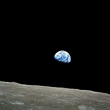
Tiŋgbani
Yi palo
Dunya
| Pahi la | Earth-Moon system |
|---|---|
| Di pilli ni | 4540 million years BCE |
| Japan zuliya (yuli kana) sabbu ni | ちきゅう |
| Siɣili-lana yuli | tankpagu, tingbani, ball |
| Dini be shɛli | inner Solar System, circumstellar habitable zone, Milky Way, Local Group |
| Coordinates of easternmost point | no value |
| Coordinates of northernmost point | 90°0′0″N 0°0′0″E |
| Coordinates of southernmost point | 90°0′0″S 0°0′0″E |
| Coordinates of westernmost point | no value |
| Highest point | Mount Everest |
| Lowest point | Challenger Deep |
| Ŋun nam | no value |
| Binyarsi yuya | 806.4616.0110 |
| Ŋun bɔhim ŋa nyɛ | earth science, geology, geophysics, planetary science |
| Yihibu saha | no value, unknown value |
| Parent astronomical body | Wuntaŋa |
| Type of orbit | heliocentric orbit |
| Wuhigi,kpihimbu, dabisili | unknown value |
| Hasitagi | Earth |
| Tuuta | flag of the Earth |
| Geography of topic | world geography |
| Nahingbaŋ | mass of the Earth, Earth's magnetic field, planetary habitability, geologic activity, narrative location |
| Taarihi bachikpani dalinli | human history, history of Earth, geological history of Earth |
| Manifestation of | open system |
| Notation | Earth symbol |
| Taɣinamsi | geoid |
| Sahinsheli yɛtɔɣa | J2000.0 |
| Demographics of topic | |
| WordLift URL | http://data.thenextweb.com/tnw/entity/earth |
| Stack Exchange tag | https://astronomy.stackexchange.com/tags/earth, https://physics.stackexchange.com/tags/earth |
| Unicode bachinima | 🜨, ♁ |
| Yaɣili | sky |
Tiŋgbani (dalinli: ![]() ; planet Earth, world)[1]
; planet Earth, world)[1]

Kundivihira
[mali niŋ | mali mi di yibu sheena n-niŋ]- ↑ Naden, Tony. 2014. Dagbani dictionary. Webonary.
Lahabali ŋɔ kuli nyɛla zaɣa ŋmaa. A ni tooi sɔŋsi Wikipedia ka ti sabi li ka di yaligi.

