Lahabali kɔligu:WestAfrica1625.png
Yi palo
WestAfrica1625.png (498 × 306 pixels, file size: 31 KB, MIME type: image/png)
Faal tarihi
Dihimi dabisili/saha n-nya kɔl' bihi kamani di ni di yina shɛm
| Zuŋɔ dabisili/Saha | Thumbnail | Di tarisi | ŋun su | tɔhibu | |
|---|---|---|---|---|---|
| din na chana | 17:42, 5 Silimin gɔli May 2010 |  | 498 × 306 (31 KB) | Omar-Toons | Reverted to version as of 00:15, 16 June 2009 |
| 18:05, 20 Silimin gɔli April 2010 |  | 497 × 306 (31 KB) | Bokpasa | Saadi dynasty and Tuaregs | |
| 00:15, 16 Silimin gɔli June 2009 |  | 498 × 306 (31 KB) | Gabagool | rm lines | |
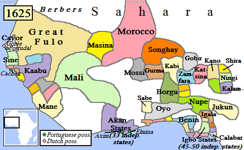
| 19:57, 19 Silimin gɔli April 2009 |  | 498 × 306 (32 KB) | Gabagool | {{Information |Description={{en|1=Map of West Africa, AD 1625. (Partially based on ''Atlas of World History'' (2007) - Early modern Africa, map.)}} |Source=Own work by uploader |Author=Gabagool |Date=2009-04-19 |Permission= |other_versi |
Lahibali kɔligu zaŋ tum tuma
Yaɣi shɛli kani din mali lahabali kɔligu ŋɔ n-kuri bukaata.
Duniya zaa lahabali kɔligu zaŋ tum tuma
Wikis shɛŋa ŋan dolina ŋɔ gba malila faal ŋɔ n kuri bukaata:
- Zaŋ tum tuma af.wikipedia.org zuɣuc
- Zaŋ tum tuma als.wikipedia.org zuɣuc
- Zaŋ tum tuma ar.wikipedia.org zuɣuc
- Zaŋ tum tuma azb.wikipedia.org zuɣuc
- Zaŋ tum tuma bn.wikipedia.org zuɣuc
- Zaŋ tum tuma ca.wikipedia.org zuɣuc
- Zaŋ tum tuma da.wikipedia.org zuɣuc
- Zaŋ tum tuma de.wikipedia.org zuɣuc
- Zaŋ tum tuma en.wikipedia.org zuɣuc
- Songhai Empire
- Songhai people
- Sahelian kingdoms
- Oyo Empire
- History of West Africa
- Islamization of the Sudan region
- Kaabu
- Empire of Great Fulo
- Dendi (province)
- Timeline of Nigerian history
- List of kingdoms and empires in African history
- Military history of the Mali Empire
- Nigerian traditional rulers
- User:OnBeyondZebrax/sandbox/African history
- The Songhai
- Medieval and early modern Africa
- History of the Mali Empire
- Zaŋ tum tuma en.wikibooks.org zuɣuc
Yulima more global usage zaŋ chaŋ lahabali kɔligu ŋɔ.


