
Lahabali kɔligu:The Perran Foundry - geograph.org.uk - 160892.jpg
Aayi di ku lahi tooi yaligi n-pahi.
The_Perran_Foundry_-_geograph.org.uk_-_160892.jpg (640 × 427 pixels, file size: 130 KB, MIME type: image/jpeg)
Lahabali jia
| Buɣisibu |
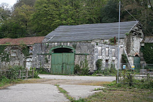
English: The Perran Foundry. This derelict industrial site awaiting "sympathetic redevelopment" is of international significance. Above the green door, the name plate shows the year 1791 as the date of establishment of the foundry. The foundry was most active from the 1820's to the 1860's when it made and shipped huge mine pumping engines all over the world. Engines created here were sent to mines in South Australia, Mexico and South Africa. Along with each engine, the company would normally send an engineer to assemble, install and run the engine.
|
|
| Dabisili kalinli | ||
| Nyabli | From geograph.org.uk | |
| Sab'sabira | Tony Atkin | |
| ŋmahinli (required by the license) | Tony Atkin / The Perran Foundry / | |
| Camera location | | View this and other nearby images on: OpenStreetMap |
|---|
_heading:112.00&language=dag)
| Object location | | View this and other nearby images on: OpenStreetMap |
|---|
_heading:112.00&language=dag)
Fukumisi shahira niŋbu

|
This image was taken from the Geograph project collection. See this photograph's page on the Geograph website for the photographer's contact details. The copyright on this image is owned by Tony Atkin and is licensed for reuse under the Creative Commons Attribution-ShareAlike 2.0 license.
|
This file is licensed under the Creative Commons Attribution-Share Alike 2.0 Generic license.
ŋmahinli: Tony Atkin
- A mali sɔli:
- N pirigi – Diyi lee ka a yan labi ŋma, n tari ka yan zaŋ tuma n talim
- Lab laɣim – n taɣi dee tuma maa
- N-yɛn zaŋ dɔli zalikpana ŋɔ sɔli:
- ŋmahindibu – Di tu ni a ti nin'tiɣili din tu, ka yooi sɔli din yihiri shiɛhira gbaŋ, ka lahi wuhi di yi niŋ ka taɣibu daa pun niŋ. A ni tooi niŋ lala ŋɔ n-doli hankali ni saɣi shɛm, amaa ka di pa sɔ'shɛli din mali biɛhiŋ zaŋ kpa ŋun tiri shiɛhira gbana ŋɔ polo nin'tiɣili ni nyini bee a zaŋ tum.
- Tarimi li din nyɛ shɛm – A yi mali labi sabi bee a taɣi li mi bee a miɛmi n-tam sabiri kurili maa zuɣu, di tu ni a tari a tɔhibu maa doli same or compatible license n-zali maŋ-maŋ maa.
Faal tarihi
Dihimi dabisili/saha n-nya kɔl' bihi kamani di ni di yina shɛm
| Zuŋɔ dabisili/Saha | Thumbnail | Di tarisi | ŋun su | tɔhibu | |
|---|---|---|---|---|---|
| din na chana | 12:46, 31 Silimin gɔli January 2010 | | 640 × 427 (130 KB) | GeographBot | == {{int:filedesc}} == {{Information |description={{en|1=The Perran Foundry. This derelict industrial site awaiting "sympathetic redevelopment" is of international significance. Above the green door, the name plate shows the year 1791 as the date of esta |
Lahibali kɔligu zaŋ tum tuma
Din doli ŋɔ na yaɣili tuma nima zaŋ ti lahabali kɔligu ŋɔ:
Duniya zaa lahabali kɔligu zaŋ tum tuma
Wikis shɛŋa ŋan dolina ŋɔ gba malila faal ŋɔ n kuri bukaata:
- Zaŋ tum tuma en.wikipedia.org zuɣuc
- Zaŋ tum tuma fa.wikipedia.org zuɣuc
- Zaŋ tum tuma gd.wikipedia.org zuɣuc
- Zaŋ tum tuma hr.wikipedia.org zuɣuc
- Zaŋ tum tuma hy.wikipedia.org zuɣuc
- Zaŋ tum tuma ru.wikipedia.org zuɣuc
- Zaŋ tum tuma sco.wikipedia.org zuɣuc
- Zaŋ tum tuma sh.wikipedia.org zuɣuc