
Lahabali kɔligu:Sacramento Skyline (cropped).jpg

Faal maa maŋmaŋa (4,030 × 1,127 pixels, file size: 1.3 MB, MIME type: image/jpeg)
.jpg)
Lahabali jia
| Buɣisibu |
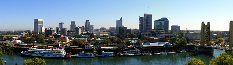
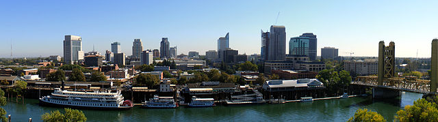
English: The Sacramento skyline, as seen from The Ziggurat in West Sacramento, California. The building is occupied by California Department of General Services who were very generous in their time in permitting me use their balcony.
Français : Le centre-ville de Sacramento, en Californie (États-Unis) vu depuis le sommet du building The Ziggurat, à West Sacramento. |
| Dabisili kalinli | |
| Nyabli | Amaŋmaŋ tuma |
| Sab'sabira | J.smith |
| Other versions |
 |
| Camera location | | View this and other nearby images on: OpenStreetMap |
|---|
.jpg¶ms=038.582861_N_-121.509389_E_globe:Earth_type:camera_heading:90.00&language=dag)
Fukumisi shahira niŋbu
- A mali sɔli:
- N pirigi – Diyi lee ka a yan labi ŋma, n tari ka yan zaŋ tuma n talim
- Lab laɣim – n taɣi dee tuma maa
- N-yɛn zaŋ dɔli zalikpana ŋɔ sɔli:
- ŋmahindibu – Di tu ni a ti nin'tiɣili din tu, ka yooi sɔli din yihiri shiɛhira gbaŋ, ka lahi wuhi di yi niŋ ka taɣibu daa pun niŋ. A ni tooi niŋ lala ŋɔ n-doli hankali ni saɣi shɛm, amaa ka di pa sɔ'shɛli din mali biɛhiŋ zaŋ kpa ŋun tiri shiɛhira gbana ŋɔ polo nin'tiɣili ni nyini bee a zaŋ tum.
- Tarimi li din nyɛ shɛm – A yi mali labi sabi bee a taɣi li mi bee a miɛmi n-tam sabiri kurili maa zuɣu, di tu ni a tari a tɔhibu maa doli same or compatible license n-zali maŋ-maŋ maa.

|
This image has been assessed under the valued image criteria and is considered the most valued image on Commons within the scope: Sacramento. You can see its nomination here. |
.jpg)
 |
This photo was taken by Justin Smith (User:J.smith) and released under the license(s) stated on this page. You are free to use this image as long as you follow the terms of the license and credit me properly. Example: © Justin Smith / Wikimedia Commons, CC-By-SA-3.0 If you use this image outside of Wikimedia projects I would appreciate (but do not require) being informed. If you would like a license with the conditions of your choice, please e-mail (commons's build-in system or at jsmith |
 |
Faal tarihi
Dihimi dabisili/saha n-nya kɔl' bihi kamani di ni di yina shɛm
| Zuŋɔ dabisili/Saha | Thumbnail | Di tarisi | ŋun su | tɔhibu | |
|---|---|---|---|---|---|
| din na chana | 00:13, 25 Silimin gɔli February 2011 | 4,030 × 1,127 (1.3 MB) | 08OceanBeach SD | brightened | |
| 02:00, 17 Silimin gɔli October 2008 | 4,030 × 1,127 (1.14 MB) | J.smith | {{Information |Description={{en|1=The Sacramento skyline, as seen from The Ziggurat in West Sacramento, California. The building is owned and occupied by California Department of General Services wh |
Lahibali kɔligu zaŋ tum tuma
Din doli ŋɔ na yaɣili tuma nima zaŋ ti lahabali kɔligu ŋɔ:
Duniya zaa lahabali kɔligu zaŋ tum tuma
Wikis shɛŋa ŋan dolina ŋɔ gba malila faal ŋɔ n kuri bukaata:
- Zaŋ tum tuma ar.wikipedia.org zuɣuc
- Zaŋ tum tuma ast.wikipedia.org zuɣuc
- Zaŋ tum tuma azb.wikipedia.org zuɣuc
- Zaŋ tum tuma bg.wikipedia.org zuɣuc
- Zaŋ tum tuma bn.wikipedia.org zuɣuc
- Zaŋ tum tuma ca.wikipedia.org zuɣuc
- Zaŋ tum tuma ckb.wikipedia.org zuɣuc
- Zaŋ tum tuma cs.wikipedia.org zuɣuc
- Zaŋ tum tuma da.wikipedia.org zuɣuc
- Zaŋ tum tuma de.wikipedia.org zuɣuc
- Zaŋ tum tuma el.wikipedia.org zuɣuc
- Zaŋ tum tuma en.wikipedia.org zuɣuc
- Sacramento, California
- Northern California
- West Coast of the United States
- List of California urban areas
- List of United States cities by population
- Downtown Sacramento
- Talk:Sacramento, California/Archive 1
- Sacramento metropolitan area
- User:Starstriker7/Sacramento Worklist
- User:08OceanBeach SD/Sandbox
- 2015 Tour of California
- User:EC35/sandbox
- Zaŋ tum tuma eo.wikipedia.org zuɣuc
- Zaŋ tum tuma et.wikipedia.org zuɣuc
- Zaŋ tum tuma eu.wikipedia.org zuɣuc
- Zaŋ tum tuma fa.wikipedia.org zuɣuc
- Zaŋ tum tuma fi.wikipedia.org zuɣuc
- Zaŋ tum tuma fo.wikipedia.org zuɣuc
- Zaŋ tum tuma fr.wikipedia.org zuɣuc
- Zaŋ tum tuma hi.wikipedia.org zuɣuc
- Zaŋ tum tuma hu.wikipedia.org zuɣuc
- Zaŋ tum tuma hy.wikipedia.org zuɣuc
- Zaŋ tum tuma hyw.wikipedia.org zuɣuc
- Zaŋ tum tuma it.wikipedia.org zuɣuc
- Zaŋ tum tuma ja.wikipedia.org zuɣuc
- Zaŋ tum tuma lb.wikipedia.org zuɣuc
- Zaŋ tum tuma li.wikipedia.org zuɣuc
- Zaŋ tum tuma lld.wikipedia.org zuɣuc
- Zaŋ tum tuma ml.wikipedia.org zuɣuc
- Zaŋ tum tuma mr.wikipedia.org zuɣuc
- Zaŋ tum tuma no.wikipedia.org zuɣuc
Yulima more global usage zaŋ chaŋ lahabali kɔligu ŋɔ.
.jpg)
.jpg)