
Lahabali kɔligu:RudstonMonolith(StephenHorncastle)Apr2006.jpg

Jɔhiyuli maa galisim:450 × 600 anfooni bihi bihi. Din pahi resolutions: 180 × 240 anfooni bihi bihi | 480 × 640 anfooni bihi bihi.
Faal maa maŋmaŋa (480 × 640 pixels, file size: 89 KB, MIME type: image/jpeg)
Apr2006.jpg)
This is a photo of listed building number 1083402. |
Lahabali jia
| Buɣisibu |
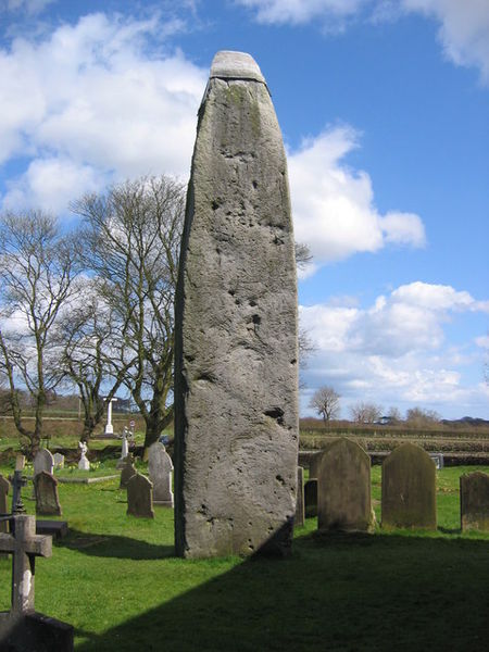
English: Rudston, East Riding of Yorkshire, England. Monolith. The stone stands almost 26ft high next to Rudston Parish Church of all Saints. Made form Moor Grit Conglomerate from the Late Neolithic Period. This material can be found in the Cleveland Hills inland from Whitby. This view to its wide face looking NE towards the B1253. |
| Dabisili kalinli | |
| Nyabli | From geograph.org.uk |
| Sab'sabira | Stephen Horncastle |
| Soli tibu (Lahabali kɔligu ŋɔ labitum zaŋ tum tuma) |
Creative Commons Attribution Share-alike license 2.0 |
| Camera location | | View this and other nearby images on: OpenStreetMap |
|---|
Apr2006.jpg¶ms=054.093919_N_-000.322512_E_globe:Earth_type:camera_heading:45.00&language=dag)
Fukumisi shahira niŋbu

|
This image was taken from the Geograph project collection. See this photograph's page on the Geograph website for the photographer's contact details. The copyright on this image is owned by Stephen Horncastle and is licensed for reuse under the Creative Commons Attribution-ShareAlike 2.0 license.
|
This file is licensed under the Creative Commons Attribution-Share Alike 2.0 Generic license.
ŋmahinli: Stephen Horncastle
- A mali sɔli:
- N pirigi – Diyi lee ka a yan labi ŋma, n tari ka yan zaŋ tuma n talim
- Lab laɣim – n taɣi dee tuma maa
- N-yɛn zaŋ dɔli zalikpana ŋɔ sɔli:
- ŋmahindibu – Di tu ni a ti nin'tiɣili din tu, ka yooi sɔli din yihiri shiɛhira gbaŋ, ka lahi wuhi di yi niŋ ka taɣibu daa pun niŋ. A ni tooi niŋ lala ŋɔ n-doli hankali ni saɣi shɛm, amaa ka di pa sɔ'shɛli din mali biɛhiŋ zaŋ kpa ŋun tiri shiɛhira gbana ŋɔ polo nin'tiɣili ni nyini bee a zaŋ tum.
- Tarimi li din nyɛ shɛm – A yi mali labi sabi bee a taɣi li mi bee a miɛmi n-tam sabiri kurili maa zuɣu, di tu ni a tari a tɔhibu maa doli same or compatible license n-zali maŋ-maŋ maa.
Faal tarihi
Dihimi dabisili/saha n-nya kɔl' bihi kamani di ni di yina shɛm
| Zuŋɔ dabisili/Saha | Thumbnail | Di tarisi | ŋun su | tɔhibu | |
|---|---|---|---|---|---|
| din na chana | 22:29, 27 Silimin gɔli December 2007 | | 480 × 640 (89 KB) | File Upload Bot (Magnus Manske) | {{BotMoveToCommons|en.wikipedia}} {{Information |Description={{en|Picture of Rudston Monolith, Yorkshire, England, taken by Stephen Horncastle in 2006 and placed on the geograph website under a Creative Commons License. Image can be seen at http://www |
Lahibali kɔligu zaŋ tum tuma
Din doli ŋɔ na yaɣili tuma nima zaŋ ti lahabali kɔligu ŋɔ:
Duniya zaa lahabali kɔligu zaŋ tum tuma
Wikis shɛŋa ŋan dolina ŋɔ gba malila faal ŋɔ n kuri bukaata:
- Zaŋ tum tuma ar.wikipedia.org zuɣuc
- Zaŋ tum tuma az.wikipedia.org zuɣuc
- Zaŋ tum tuma be.wikipedia.org zuɣuc
- Zaŋ tum tuma bn.wikipedia.org zuɣuc
- Zaŋ tum tuma de.wikipedia.org zuɣuc
- Zaŋ tum tuma en.wikipedia.org zuɣuc
- Zaŋ tum tuma et.wikipedia.org zuɣuc
- Zaŋ tum tuma fr.wikipedia.org zuɣuc
- Zaŋ tum tuma hu.wikipedia.org zuɣuc
- Zaŋ tum tuma hy.wikipedia.org zuɣuc
- Zaŋ tum tuma it.wikipedia.org zuɣuc
- Zaŋ tum tuma lv.wikipedia.org zuɣuc
- Zaŋ tum tuma nl.wikipedia.org zuɣuc
- Zaŋ tum tuma ru.wikipedia.org zuɣuc
- Zaŋ tum tuma sv.wikipedia.org zuɣuc
- Zaŋ tum tuma tt.wikipedia.org zuɣuc
- Zaŋ tum tuma vi.wikipedia.org zuɣuc
- Zaŋ tum tuma zh.wikipedia.org zuɣuc
Apr2006.jpg)