
Lahabali kɔligu:River Nith estuary.jpg

Jɔhiyuli maa galisim:800 × 533 anfooni bihi bihi. Din pahi resolutions: 320 × 213 anfooni bihi bihi | 640 × 427 anfooni bihi bihi | 1,024 × 683 anfooni bihi bihi | 1,280 × 853 anfooni bihi bihi | 2,560 × 1,707 anfooni bihi bihi | 3,504 × 2,336 anfooni bihi bihi.
Faal maa maŋmaŋa (3,504 × 2,336 pixels, file size: 8.68 MB, MIME type: image/jpeg)
Lahabali jia
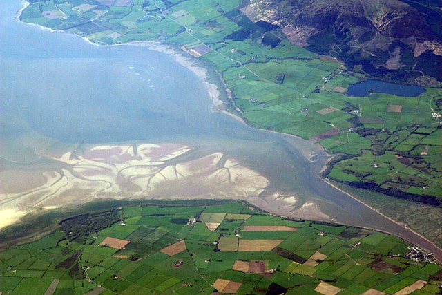
| Buɣisibu | The estuary of the River Nith, Scotland, at low tide; opening into Solway Firth. This is a view of the Nith estuary from the north-east. The group of buildings at bottom right is the village of Glencaple. At bottom left near the wooded area is Caerlaverock Castle. At top right is Loch Kindar and the hill above is called Criffel. Just beyond the top left of photo is the birthplace of John Paul Jones. |
| Dabisili kalinli | |
| Nyabli | https://www.flickr.com/photos/52614599@N00/483602946 |
| Sab'sabira | Doc Searls from Santa Barbara, USA |
Fukumisi shahira niŋbu
This file is licensed under the Creative Commons Attribution-Share Alike 2.0 Generic license.
- A mali sɔli:
- N pirigi – Diyi lee ka a yan labi ŋma, n tari ka yan zaŋ tuma n talim
- Lab laɣim – n taɣi dee tuma maa
- N-yɛn zaŋ dɔli zalikpana ŋɔ sɔli:
- ŋmahindibu – Di tu ni a ti nin'tiɣili din tu, ka yooi sɔli din yihiri shiɛhira gbaŋ, ka lahi wuhi di yi niŋ ka taɣibu daa pun niŋ. A ni tooi niŋ lala ŋɔ n-doli hankali ni saɣi shɛm, amaa ka di pa sɔ'shɛli din mali biɛhiŋ zaŋ kpa ŋun tiri shiɛhira gbana ŋɔ polo nin'tiɣili ni nyini bee a zaŋ tum.
- Tarimi li din nyɛ shɛm – A yi mali labi sabi bee a taɣi li mi bee a miɛmi n-tam sabiri kurili maa zuɣu, di tu ni a tari a tɔhibu maa doli same or compatible license n-zali maŋ-maŋ maa.
| This image was originally posted to Flickr by dsearls at https://www.flickr.com/photos/52614599@N00/483602946. It was reviewed on 5 Silimin gɔli May 2007 by FlickreviewR and was confirmed to be licensed under the terms of the cc-by-sa-2.0. |
This is a view of the Nith estuary from the north-east. The group of buildings at bottom right is the village of Glencaple. At bottom left near the wooded area is Caerlaverock Castle. At top right is Loch Kindar and the hill above is called Criffel. Just beyond the top left of photo is the birthplace of John Paul Jones.
Faal tarihi
Dihimi dabisili/saha n-nya kɔl' bihi kamani di ni di yina shɛm
| Zuŋɔ dabisili/Saha | Thumbnail | Di tarisi | ŋun su | tɔhibu | |
|---|---|---|---|---|---|
| din na chana | 07:14, 5 Silimin gɔli May 2007 | | 3,504 × 2,336 (8.68 MB) | Sandstein | {{Information |Description= The estuary of the River Nith, Scotland, at low tide; opening into Solway Firth. On the near shore, Bowness-on-Solway. On the far, Annan, in Dumfries and Galloway. |Source= http://www.flickr.com/photos/52614599@N00/483602946 |D |
Lahibali kɔligu zaŋ tum tuma
Din doli ŋɔ na yaɣili tuma nima zaŋ ti lahabali kɔligu ŋɔ:
Duniya zaa lahabali kɔligu zaŋ tum tuma
Wikis shɛŋa ŋan dolina ŋɔ gba malila faal ŋɔ n kuri bukaata:
- Zaŋ tum tuma ar.wikipedia.org zuɣuc
- Zaŋ tum tuma arz.wikipedia.org zuɣuc
- Zaŋ tum tuma ast.wikipedia.org zuɣuc
- Zaŋ tum tuma bn.wikipedia.org zuɣuc
- Zaŋ tum tuma br.wikipedia.org zuɣuc
- Zaŋ tum tuma ceb.wikipedia.org zuɣuc
- Zaŋ tum tuma cs.wikipedia.org zuɣuc
- Zaŋ tum tuma cy.wikipedia.org zuɣuc
- Zaŋ tum tuma de.wikipedia.org zuɣuc
- Zaŋ tum tuma en.wikipedia.org zuɣuc
- Zaŋ tum tuma en.wikivoyage.org zuɣuc
- Zaŋ tum tuma eo.wikipedia.org zuɣuc
- Zaŋ tum tuma es.wikipedia.org zuɣuc
- Zaŋ tum tuma eu.wikipedia.org zuɣuc
- Zaŋ tum tuma fa.wikipedia.org zuɣuc
- Zaŋ tum tuma fr.wikipedia.org zuɣuc
- Zaŋ tum tuma fy.wikipedia.org zuɣuc
- Zaŋ tum tuma ga.wikipedia.org zuɣuc
- Zaŋ tum tuma gd.wikipedia.org zuɣuc
- Zaŋ tum tuma gv.wikipedia.org zuɣuc
- Zaŋ tum tuma hak.wikipedia.org zuɣuc
- Zaŋ tum tuma id.wikipedia.org zuɣuc
- Zaŋ tum tuma incubator.wikimedia.org zuɣuc
- Zaŋ tum tuma it.wikipedia.org zuɣuc
- Zaŋ tum tuma it.wikibooks.org zuɣuc
- Zaŋ tum tuma it.wikiversity.org zuɣuc
- Zaŋ tum tuma ja.wikipedia.org zuɣuc
- Zaŋ tum tuma kbd.wikipedia.org zuɣuc
- Zaŋ tum tuma lt.wikipedia.org zuɣuc
- Zaŋ tum tuma nl.wikipedia.org zuɣuc
Yulima more global usage zaŋ chaŋ lahabali kɔligu ŋɔ.