
Lahabali kɔligu:Pestilence spreading 1347-1351 europe.png

Faal maa maŋmaŋa (1,280 × 1,387 pixels, file size: 350 KB, MIME type: image/png)
| Buɣisibu |
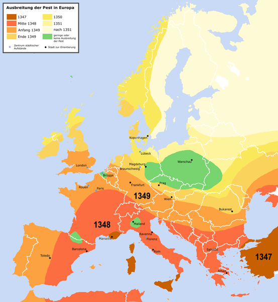
English: Spreading of the en:Black Death in Europe between 1347 and 1351, apparently copied from a work called "Atlas zur Weltgeschichte" (perhaps dtv-Atlas? If so, Kinder and Hilgemann (eds.), dtv-Atlas zur Weltgeschichte was published in 35(!) editions between 1964 and 2002, and it would be crucial to know which edition we are basing this on).
The details of the map are to be taken with a large grain of salt. It is roughly compatible with this Britannica map (copy, dated 1994), but the details vary significantly. Other significant differences exist with this map (an unreferenced scan of a professional publication), where e.g. the area of Poland/Silesia marked "unaffected" in this map is part of a much larger area marked as "Area for which there is insufficient information". Here is another map with a somewhat more conservative epistemology, referenced to "insecta-inspecta.com", where it was posted in 2000 (and therefore uninfluenced by the 2005 upload of this map). An academically published map for comparison: [1] cited to: D. Sherman and J. Salisbury, The West in the World: Volume I to 1715. McGraw-Hill, Boston, 3rd edition (2008), not necessarily better than the Britannica map, as it is a rough sketched used for the purposes of some argument about network theory, and not a medievalist publication dedicated to the history of the Black Death as such.Deutsch: Ausbreitung der de:Pest in Europa zwischen 1347 und 1351 |
| Dabisili kalinli | |
| Nyabli | "Atlas zur Weltgeschichte"(?) |
| Sab'sabira | Roger_Zenner |
| Soli tibu (Lahabali kɔligu ŋɔ labitum zaŋ tum tuma) |
Creative Commons by/sa/de |
| Other versions |
[] Better than many files each for one language is to create one multilanguaged file (SVG switch option).
|


- Version 1.1
- Changelog: 1.0: new map -> 1.1: more details, color changes, more cities
- A mali sɔli:
- N pirigi – Diyi lee ka a yan labi ŋma, n tari ka yan zaŋ tuma n talim
- Lab laɣim – n taɣi dee tuma maa
- N-yɛn zaŋ dɔli zalikpana ŋɔ sɔli:
- ŋmahindibu – Di tu ni a ti nin'tiɣili din tu, ka yooi sɔli din yihiri shiɛhira gbaŋ, ka lahi wuhi di yi niŋ ka taɣibu daa pun niŋ. A ni tooi niŋ lala ŋɔ n-doli hankali ni saɣi shɛm, amaa ka di pa sɔ'shɛli din mali biɛhiŋ zaŋ kpa ŋun tiri shiɛhira gbana ŋɔ polo nin'tiɣili ni nyini bee a zaŋ tum.
- Tarimi li din nyɛ shɛm – A yi mali labi sabi bee a taɣi li mi bee a miɛmi n-tam sabiri kurili maa zuɣu, di tu ni a tari a tɔhibu maa doli same or compatible license n-zali maŋ-maŋ maa.

Faal tarihi
Dihimi dabisili/saha n-nya kɔl' bihi kamani di ni di yina shɛm
| Zuŋɔ dabisili/Saha | Thumbnail | Di tarisi | ŋun su | tɔhibu | |
|---|---|---|---|---|---|
| din na chana | 22:42, 3 Silimin gɔli April 2016 | | 1,280 × 1,387 (350 KB) | Poeticbent | made the map readable again |
| 01:32, 24 Silimin gɔli May 2015 |  | 1,280 × 1,387 (330 KB) | Alphathon | Removed border in Northern Serbia (seems roughly correspond to the Autonomous Province of Vojvodina; shouldn't be on there regardless). Added border between Montenegro and Serbia (which separated in 2006). Also added Kosovo border. | |
| 13:18, 21 Silimin gɔli January 2010 |  | 1,280 × 1,387 (304 KB) | Chesnok | deleted artificial Rybinsk reservoir and reservoirs on Dnieper | |
| 03:46, 3 Silimin gɔli April 2005 |  | 1,280 × 1,387 (378 KB) | Roger Zenner | ||
| 03:30, 3 Silimin gɔli April 2005 |  | 1,280 × 1,354 (394 KB) | Roger Zenner | ||
| 02:17, 3 Silimin gɔli April 2005 |  | 1,280 × 1,346 (373 KB) | Roger Zenner | *'''english''': spreading of the en:pest in Europe between 1347 and 1351 *'''deutsch''': Ausbreitung der de:Pest in Europa zwischen 1347 und 1351 *License: Creative Commons by/sa/de *Author: Roger_Zenner *Date: 2005/03/04 |
Lahibali kɔligu zaŋ tum tuma
Yaɣi shɛli kani din mali lahabali kɔligu ŋɔ n-kuri bukaata.
Duniya zaa lahabali kɔligu zaŋ tum tuma
Wikis shɛŋa ŋan dolina ŋɔ gba malila faal ŋɔ n kuri bukaata:
- Zaŋ tum tuma als.wikipedia.org zuɣuc
- Zaŋ tum tuma an.wikipedia.org zuɣuc
- Zaŋ tum tuma arz.wikipedia.org zuɣuc
- Zaŋ tum tuma azb.wikipedia.org zuɣuc
- Zaŋ tum tuma bg.wikipedia.org zuɣuc
- Zaŋ tum tuma cy.wikipedia.org zuɣuc
- Zaŋ tum tuma de.wikipedia.org zuɣuc
- Zaŋ tum tuma de.wikibooks.org zuɣuc
- Zaŋ tum tuma frr.wikipedia.org zuɣuc
- Zaŋ tum tuma fr.wikipedia.org zuɣuc
- Zaŋ tum tuma gl.wikipedia.org zuɣuc
- Zaŋ tum tuma hu.wikipedia.org zuɣuc
- Zaŋ tum tuma hy.wikipedia.org zuɣuc
- Zaŋ tum tuma ia.wikipedia.org zuɣuc
- Zaŋ tum tuma incubator.wikimedia.org zuɣuc
- Zaŋ tum tuma io.wikipedia.org zuɣuc
- Zaŋ tum tuma lad.wikipedia.org zuɣuc
- Zaŋ tum tuma la.wikipedia.org zuɣuc
- Zaŋ tum tuma nl.wikipedia.org zuɣuc
- Zaŋ tum tuma sl.wikipedia.org zuɣuc
- Zaŋ tum tuma www.wikidata.org zuɣuc
- Zaŋ tum tuma zh-min-nan.wikipedia.org zuɣuc