
Lahabali kɔligu:Libya 4985 Tadrart Acacus Luca Galuzzi 2007.jpg
Faal maa maŋmaŋa (2,000 × 1,333 pixels, file size: 1.65 MB, MIME type: image/jpeg)
|

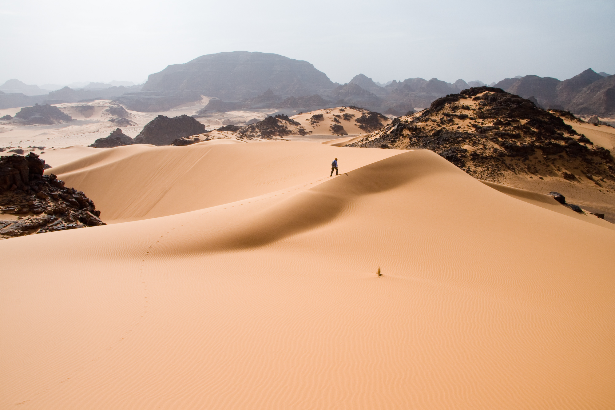
This image was selected as picture of the day on Wikimedia Commons for 5 March 2009. It was captioned as follows: English: Leaving traces on soft sand dunes in Tadrart Acacus a desert area in western Libya, part of the Sahara. Other languages:
Afrikaans: Die duinveld (of sandsee, 'n sg. erg), aan die voet van die Akakusgebergte in suidwestelike Libië Bosanski: Ostavljanje tragova na mekim pješčanim dinama u Tadrart Acacus-u, pustinjskoj oblasti u zapadnj Libiji, dijelu Sahare. Dansk: Fodspor afsættes i klitter af blødt sand i Tadrart Acacus, et ørkenområde i det vestlige Libyen. English: Leaving traces on soft sand dunes in Tadrart Acacus a desert area in western Libya, part of the Sahara. Español: Dejando huellas en la arena de las dunas de Tadrart Acacus, una zona desértica del oeste de Libia, parte del Sahara. Français : Dunes de sable doux dans Tadrart Acacus, une partie du désert de l'ouest de la Libye, dans le Sahara. Íslenska: Spor í mjúkum sandöldum í Tadrart Acacus, eyðimerkursvæði í Líbýu sem er hluti af Sahara-eyðimörkinni. Português: Dunas em Tadrart Acacus, uma área desértica no Leste da Líbia Suomi: Jälkien jättämistä pehmeisiin hiekkadyyneihin Tadrart Acacus -aavikolle läntisessä Libyassa, osassa Saharan autiomaata. العربية : كثبان الرمال غرب ليبيا |
شًط دبًيي يد
Lahabali jia
| Buɣisibu |
العربية: آثار مشي أحد الأشخاص على كُثبان الرِّمال الناعمة في جبال أكاكوس، وهي إحدى المناطق الصحراويَّة الواقعة في غرب ليبيا، وتُشكِّلُ جُزءًا من الصحراء الكُبرى.
English: Leaving traces on soft sand dunes in Tadrart Acacus a desert area in western Libya, part of the Sahara.
Français : Un marcheur laisse des empreintes sur le sable mou des dunes de Tadrart Acacus, une zone désertique de l'ouest libyen appartenant au Sahara.
Italiano: Tracce lasciate sulle soffici dune di sabbia nel Tadrart Acacus, un'area deserta nel sud-ovest libico, deserto del Sahara. |
||
| Dabisili kalinli | |||
| Nyabli | Photo taken by (Luca Galuzzi) * http://www.galuzzi.it | ||
| Sab'sabira | Luca Galuzzi (Lucag) | ||
| Soli tibu (Lahabali kɔligu ŋɔ labitum zaŋ tum tuma) |
I, Luca Galuzzi, the copyright holder of this work, hereby publishes it under the following license: This file is licensed under the Creative Commons Attribution-Share Alike 2.5 Generic license. ŋmahinli: I, Luca Galuzzi
|

| Camera location | | View this and other nearby images on: OpenStreetMap |
|---|
Faal tarihi
Dihimi dabisili/saha n-nya kɔl' bihi kamani di ni di yina shɛm
| Zuŋɔ dabisili/Saha | Thumbnail | Di tarisi | ŋun su | tɔhibu | |
|---|---|---|---|---|---|
| din na chana | 17:11, 18 Silimin gɔli November 2007 | | 2,000 × 1,333 (1.65 MB) | Lucag | |
| 21:58, 29 Silimin gɔli May 2007 |  | 2,000 × 1,333 (1.85 MB) | Lucag | {{Information |Description={{en|Crossing soft sand dunes in Tadrart Acacus a desert area in western Libya, part of the Sahara.}} {{it|Attraversamento di soffici dune di sabbia nel Tadrart Acacus, un'area deserta nel sud-ovest libico, deserto del Sahara.}} |
Lahibali kɔligu zaŋ tum tuma
Din doli ŋɔ na yaɣili tuma nima zaŋ ti lahabali kɔligu ŋɔ:
Duniya zaa lahabali kɔligu zaŋ tum tuma
Wikis shɛŋa ŋan dolina ŋɔ gba malila faal ŋɔ n kuri bukaata:
- Zaŋ tum tuma am.wikipedia.org zuɣuc
- Zaŋ tum tuma arc.wikipedia.org zuɣuc
- Zaŋ tum tuma ar.wikipedia.org zuɣuc
- بوابة:إفريقيا
- جبال أكاكوس
- بوابة:إفريقيا/مقالة مختارة/أرشيف
- ويكيبيديا:صور مختارة/أماكن/مناظر طبيعية
- ويكيبيديا:ترشيحات الصور المختارة/الصحراء في جبال أكاكوس
- بوابة:ليبيا/صورة مختارة/22
- بوابة:ليبيا/صورة مختارة/أرشيف
- بوابة:إفريقيا/مقالة مختارة/2
- ويكيبيديا:صورة اليوم المختارة/ديسمبر 2015
- قالب:صورة اليوم المختارة/2015-12-04
- ويكيبيديا:صورة اليوم المختارة/يناير 2019
- قالب:صورة اليوم المختارة/2019-01-06
- مستخدم:أريام البلوشي/ملعب
- ويكيبيديا:صورة اليوم المختارة/يونيو 2021
- قالب:صورة اليوم المختارة/2021-06-20
- مستخدم:NANöR/جبال أكاكوس
- المنطقة البيئية الصحراوية
- Zaŋ tum tuma ast.wikipedia.org zuɣuc
- Zaŋ tum tuma as.wikipedia.org zuɣuc
- Zaŋ tum tuma azb.wikipedia.org zuɣuc
- Zaŋ tum tuma az.wikipedia.org zuɣuc
- Zaŋ tum tuma ba.wikipedia.org zuɣuc
- Zaŋ tum tuma be.wikipedia.org zuɣuc
- Zaŋ tum tuma bg.wikipedia.org zuɣuc
- Zaŋ tum tuma bn.wikipedia.org zuɣuc
- Zaŋ tum tuma bn.wikivoyage.org zuɣuc
- Zaŋ tum tuma br.wikipedia.org zuɣuc
- Zaŋ tum tuma ca.wikipedia.org zuɣuc
- Zaŋ tum tuma ceb.wikipedia.org zuɣuc
- Zaŋ tum tuma crh.wikipedia.org zuɣuc
- Zaŋ tum tuma csb.wikipedia.org zuɣuc
- Zaŋ tum tuma cv.wikipedia.org zuɣuc
- Zaŋ tum tuma de.wikipedia.org zuɣuc
- Zaŋ tum tuma de.wikinews.org zuɣuc
- Zaŋ tum tuma din.wikipedia.org zuɣuc
- Zaŋ tum tuma dty.wikipedia.org zuɣuc
- Zaŋ tum tuma en.wikipedia.org zuɣuc
Yulima more global usage zaŋ chaŋ lahabali kɔligu ŋɔ.