
Lahabali kɔligu:Kanawha Ohio confluence.jpg

Jɔhiyuli maa galisim:751 × 600 anfooni bihi bihi. Din pahi resolutions: 301 × 240 anfooni bihi bihi | 601 × 480 anfooni bihi bihi | 962 × 768 anfooni bihi bihi | 1,280 × 1,022 anfooni bihi bihi | 1,500 × 1,198 anfooni bihi bihi.
Faal maa maŋmaŋa (1,500 × 1,198 pixels, file size: 724 KB, MIME type: image/jpeg)
Lahabali jia
| Buɣisibu |
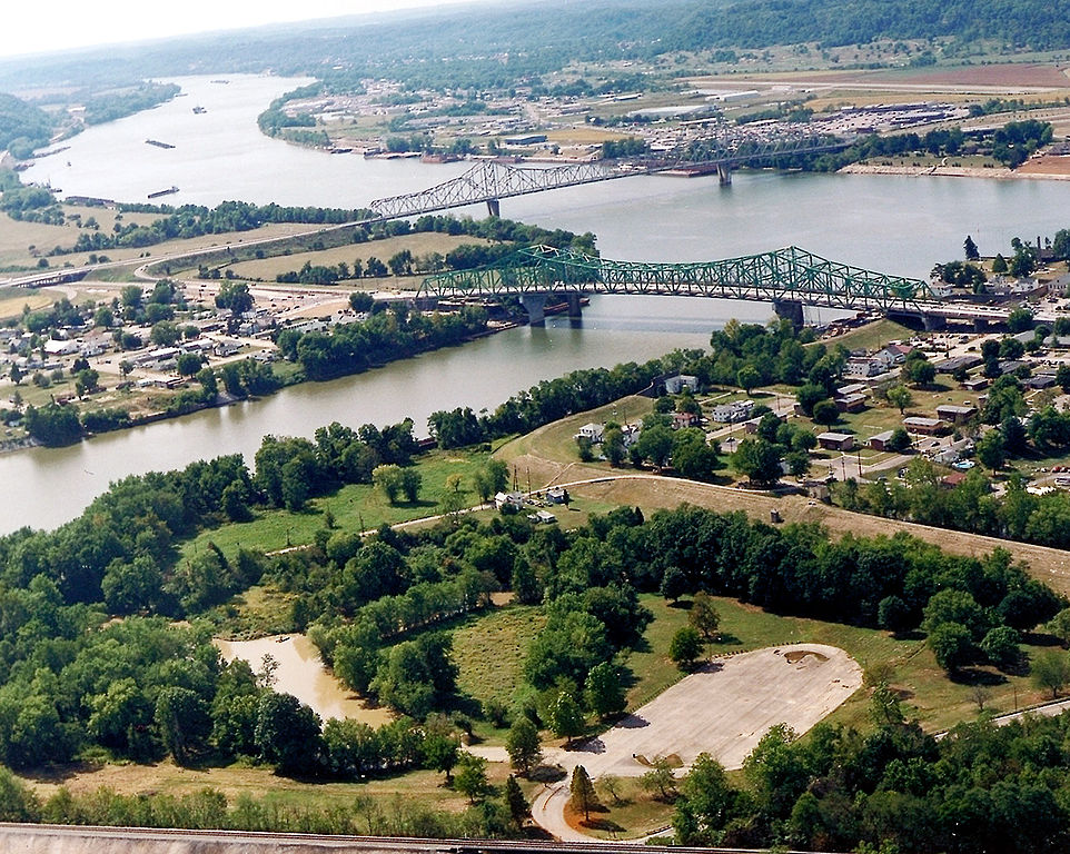
English: The confluence of the Kanawha and Ohio Rivers. The Kanawha River flows in from the left of the picture and joins the Ohio, meandering off in the distance. The town of Point Pleasant, West Virginia is in the foreground on the right. Henderson, West Virginia is on the left. The Ohio River forms the boundary between West Virginia and Ohio. The town of Gallipolis, Ohio lies in the far distance across the Ohio River. The view is to the west-southwest down the river. |
|||
| Dabisili kalinli | before 2007 | |||
| Nyabli |
U.S. Army Corps of Engineers Digital Visual Library Image page Image description page Digital Visual Library home page |
|||
| Sab'sabira | Charles Johnson, U.S. Army Corps of Engineers | |||
| Soli tibu (Lahabali kɔligu ŋɔ labitum zaŋ tum tuma) |
|
|||
| Location | Point Pleasant, West Virginia, USA |
| Camera location | | View this and other nearby images on: OpenStreetMap |
|---|
| Annotations | This image is annotated: View the annotations at Commons |
Faal tarihi
Dihimi dabisili/saha n-nya kɔl' bihi kamani di ni di yina shɛm
| Zuŋɔ dabisili/Saha | Thumbnail | Di tarisi | ŋun su | tɔhibu | |
|---|---|---|---|---|---|
| din na chana | 04:52, 23 Silimin gɔli March 2007 | | 1,500 × 1,198 (724 KB) | DanMS | {{Information | Description = {{en|The confluence of the Kanawha and Ohio Rivers. The Kanawha River flows in from the left of the picture and joins the Ohio, meandering off in the distance. The town of Point Pleasant, West Virginia is in the foreground |
Lahibali kɔligu zaŋ tum tuma
Din doli ŋɔ na yaɣili tuma nima zaŋ ti lahabali kɔligu ŋɔ:
Duniya zaa lahabali kɔligu zaŋ tum tuma
Wikis shɛŋa ŋan dolina ŋɔ gba malila faal ŋɔ n kuri bukaata:
- Zaŋ tum tuma ar.wikipedia.org zuɣuc
- Zaŋ tum tuma arz.wikipedia.org zuɣuc
- Zaŋ tum tuma ca.wikipedia.org zuɣuc
- Zaŋ tum tuma ceb.wikipedia.org zuɣuc
- Zaŋ tum tuma ce.wikipedia.org zuɣuc
- Zaŋ tum tuma cy.wikipedia.org zuɣuc
- Zaŋ tum tuma de.wikipedia.org zuɣuc
- Zaŋ tum tuma en.wikipedia.org zuɣuc
- Zaŋ tum tuma en.wikivoyage.org zuɣuc
- Zaŋ tum tuma es.wikipedia.org zuɣuc
- Zaŋ tum tuma eu.wikipedia.org zuɣuc
- Zaŋ tum tuma fa.wikipedia.org zuɣuc
- Zaŋ tum tuma fr.wikipedia.org zuɣuc
- Zaŋ tum tuma hu.wikipedia.org zuɣuc
- Zaŋ tum tuma it.wikipedia.org zuɣuc
- Zaŋ tum tuma ja.wikipedia.org zuɣuc
- Zaŋ tum tuma ko.wikipedia.org zuɣuc
- Zaŋ tum tuma kw.wikipedia.org zuɣuc
- Zaŋ tum tuma lld.wikipedia.org zuɣuc
- Zaŋ tum tuma no.wikipedia.org zuɣuc
- Zaŋ tum tuma pl.wikipedia.org zuɣuc
- Zaŋ tum tuma pt.wikipedia.org zuɣuc
- Zaŋ tum tuma ro.wikipedia.org zuɣuc
- Zaŋ tum tuma ru.wikipedia.org zuɣuc
- Zaŋ tum tuma sh.wikipedia.org zuɣuc
- Zaŋ tum tuma simple.wikipedia.org zuɣuc
- Zaŋ tum tuma sr.wikipedia.org zuɣuc
- Zaŋ tum tuma tt.wikipedia.org zuɣuc
Yulima more global usage zaŋ chaŋ lahabali kɔligu ŋɔ.