
Lahabali kɔligu:Eye Manor - 1 - geograph.org.uk - 1282071.jpg
Eye_Manor_-_1_-_geograph.org.uk_-_1282071.jpg (640 × 480 pixels, file size: 126 KB, MIME type: image/jpeg)
Lahabali jia
| Buɣisibu |
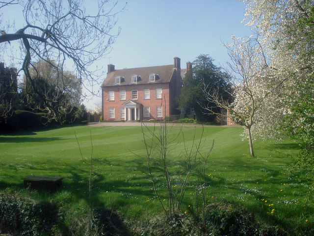
English: Eye Manor - 1 Looking west to the front lawn and main entrance, with Eye church in the trees on the extreme left.
This house has a rich history. Built in 1673-80 for Sir Fernando Gorges, a wealthy merchant and promoter of colonization in America. He was the founder of Maine. http://www.thehistorychannel.co.uk/site/encyclopedia/article_show/Gorges_Ferdinando_c_15661647_/m0053346.html?&searchtermold=henry%20viii&searchtermold=henry%20viii In the 20th century, it was the home of Jeremy Sandler, author of Cathy Come Home. http://www.guardian.co.uk/news/2003/may/15/guardianobituaries The exciting thing about the house, which is privately owned, is its fabulous interior, including carvings by Grinling Gibbons.... http://property.timesonline.co.uk/tol/life_and_style/property/buying_and_selling/article4824205.ece http://www.britainexpress.com/History/gibbons.htm |
| Dabisili kalinli | |
| Nyabli | From geograph.org.uk |
| Sab'sabira | Trevor Rickard |
| ŋmahinli (required by the license) | Trevor Rickard / Eye Manor - 1 / |
| Camera location | | View this and other nearby images on: OpenStreetMap |
|---|
_heading:270.00&language=dag)
| Object location | | View this and other nearby images on: OpenStreetMap |
|---|
_heading:270.00&language=dag)
Fukumisi shahira niŋbu

|
This image was taken from the Geograph project collection. See this photograph's page on the Geograph website for the photographer's contact details. The copyright on this image is owned by Trevor Rickard and is licensed for reuse under the Creative Commons Attribution-ShareAlike 2.0 license.
|
- A mali sɔli:
- N pirigi – Diyi lee ka a yan labi ŋma, n tari ka yan zaŋ tuma n talim
- Lab laɣim – n taɣi dee tuma maa
- N-yɛn zaŋ dɔli zalikpana ŋɔ sɔli:
- ŋmahindibu – Di tu ni a ti nin'tiɣili din tu, ka yooi sɔli din yihiri shiɛhira gbaŋ, ka lahi wuhi di yi niŋ ka taɣibu daa pun niŋ. A ni tooi niŋ lala ŋɔ n-doli hankali ni saɣi shɛm, amaa ka di pa sɔ'shɛli din mali biɛhiŋ zaŋ kpa ŋun tiri shiɛhira gbana ŋɔ polo nin'tiɣili ni nyini bee a zaŋ tum.
- Tarimi li din nyɛ shɛm – A yi mali labi sabi bee a taɣi li mi bee a miɛmi n-tam sabiri kurili maa zuɣu, di tu ni a tari a tɔhibu maa doli same or compatible license n-zali maŋ-maŋ maa.
Faal tarihi
Dihimi dabisili/saha n-nya kɔl' bihi kamani di ni di yina shɛm
| Zuŋɔ dabisili/Saha | Thumbnail | Di tarisi | ŋun su | tɔhibu | |
|---|---|---|---|---|---|
| din na chana | 05:59, 27 Silimin gɔli February 2011 | | 640 × 480 (126 KB) | GeographBot | == {{int:filedesc}} == {{Information |description={{en|1=Eye Manor - 1 Looking west to the front lawn and main entrance, with Eye church in the trees on the extreme left. This house has a rich history. Built in 1673-80 for Sir Fernando Gorges, a wealthy |
Lahibali kɔligu zaŋ tum tuma
Din doli ŋɔ na yaɣili tuma nima zaŋ ti lahabali kɔligu ŋɔ:
Duniya zaa lahabali kɔligu zaŋ tum tuma
Wikis shɛŋa ŋan dolina ŋɔ gba malila faal ŋɔ n kuri bukaata:
- Zaŋ tum tuma en.wikipedia.org zuɣuc
- Zaŋ tum tuma www.wikidata.org zuɣuc