
Lahabali kɔligu:Crookston Commercial Historic District.jpg

Jɔhiyuli maa galisim:757 × 599 anfooni bihi bihi. Din pahi resolutions: 303 × 240 anfooni bihi bihi | 606 × 480 anfooni bihi bihi | 956 × 757 anfooni bihi bihi.
Faal maa maŋmaŋa (956 × 757 pixels, file size: 84 KB, MIME type: image/jpeg)
|
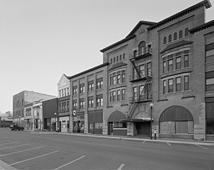
This is an image of a place or building that is listed on the National Register of Historic Places in the United States of America. Its reference number is 84002709. |
| Buɣisibu |
English: Buildings in the Crookston Commercial Historic District in central Crookston, Polk County, Minnesota, United States. The district reflects the city's early period of growth, which was prompted by agriculture and the railroad industry. It remains a large, and mostly intact, concentration of late nineteenth- and early twentieth-century commercial structures and is listed on the National Register of Historic Places. |
|||||
| Dabisili kalinli | Unknown date | |||||
| Nyabli | Library of Congress Prints and Photographs Division, Historic American Buildings Survey: MINN,60-CROK,1-6 | |||||
| Sab'sabira | Anonymous | |||||
| Soli tibu (Lahabali kɔligu ŋɔ labitum zaŋ tum tuma) |
|

| Object location | | View this and other nearby images on: OpenStreetMap |
|---|

|
This image is available from the United States Library of Congress's Prints and Photographs division
under the digital ID hhh.mn0444. This tag does not indicate the copyright status of the attached work. A normal copyright tag is still required. See Commons:Licensing.
|
Faal tarihi
Dihimi dabisili/saha n-nya kɔl' bihi kamani di ni di yina shɛm
| Zuŋɔ dabisili/Saha | Thumbnail | Di tarisi | ŋun su | tɔhibu | |
|---|---|---|---|---|---|
| din na chana | 14:07, 31 Silimin gɔli January 2009 | | 956 × 757 (84 KB) | Cropbot | upload cropped version, operated by User:Finavon. Summary: border cropped |
| 14:35, 29 Silimin gɔli January 2009 |  | 1,024 × 818 (96 KB) | Nyttend | {{Information |Description=Photograph from the {{w|Historic American Buildings Survey}} of buildings in the {{w|Crookston Commercial Historic District}}, an area listed on the {{w|National Register of Historic Places}}. The district is located in central |
Lahibali kɔligu zaŋ tum tuma
Din doli ŋɔ na yaɣili tuma nima zaŋ ti lahabali kɔligu ŋɔ:
Duniya zaa lahabali kɔligu zaŋ tum tuma
Wikis shɛŋa ŋan dolina ŋɔ gba malila faal ŋɔ n kuri bukaata:
- Zaŋ tum tuma ar.wikipedia.org zuɣuc
- Zaŋ tum tuma arz.wikipedia.org zuɣuc
- Zaŋ tum tuma azb.wikipedia.org zuɣuc
- Zaŋ tum tuma be.wikipedia.org zuɣuc
- Zaŋ tum tuma ca.wikipedia.org zuɣuc
- Zaŋ tum tuma ceb.wikipedia.org zuɣuc
- Zaŋ tum tuma ce.wikipedia.org zuɣuc
- Zaŋ tum tuma de.wikipedia.org zuɣuc
- Zaŋ tum tuma en.wikipedia.org zuɣuc
- Zaŋ tum tuma en.wikivoyage.org zuɣuc
- Zaŋ tum tuma es.wikipedia.org zuɣuc
- Zaŋ tum tuma eu.wikipedia.org zuɣuc
- Zaŋ tum tuma fa.wikipedia.org zuɣuc
- Zaŋ tum tuma fr.wikipedia.org zuɣuc
- Zaŋ tum tuma ht.wikipedia.org zuɣuc
- Zaŋ tum tuma hu.wikipedia.org zuɣuc
- Zaŋ tum tuma ia.wikipedia.org zuɣuc
- Zaŋ tum tuma ko.wikipedia.org zuɣuc
- Zaŋ tum tuma ky.wikipedia.org zuɣuc
- Zaŋ tum tuma lld.wikipedia.org zuɣuc
- Zaŋ tum tuma pt.wikipedia.org zuɣuc
- Zaŋ tum tuma ru.wikipedia.org zuɣuc
- Zaŋ tum tuma sh.wikipedia.org zuɣuc
- Zaŋ tum tuma sr.wikipedia.org zuɣuc
- Zaŋ tum tuma tr.wikipedia.org zuɣuc
- Zaŋ tum tuma tt.wikipedia.org zuɣuc
- Zaŋ tum tuma uk.wikipedia.org zuɣuc
- Zaŋ tum tuma ur.wikipedia.org zuɣuc
- Zaŋ tum tuma uz.wikipedia.org zuɣuc
- Zaŋ tum tuma vi.wikipedia.org zuɣuc
- Zaŋ tum tuma www.wikidata.org zuɣuc
- Zaŋ tum tuma zh-min-nan.wikipedia.org zuɣuc