
Lahabali kɔligu:Buckshaw Hall - geograph.org.uk - 1097081.jpg
Aayi di ku lahi tooi yaligi n-pahi.
Buckshaw_Hall_-_geograph.org.uk_-_1097081.jpg (640 × 480 pixels, file size: 98 KB, MIME type: image/jpeg)
Lahabali jia
| Buɣisibu |
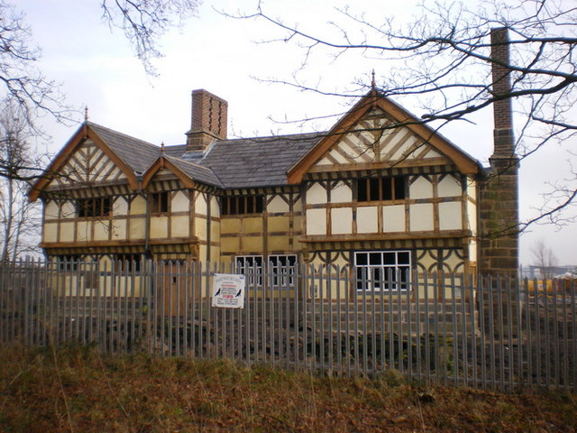
English: Buckshaw Hall. Was built in 1650s by the Robinson family.This two storey timber hall had its central part flanked by two protruding gables, one at each end with two brick chimneys built into northerly and southerly elevations. The hall stayed in private possession until around 1937 when it was purchased, with the accompanying farmland, by the R.O.F. to build a munitions factory. Nearing its complete restoration, the hall will eventually be sold. Link to a photo circa 2005 18039 |
| Dabisili kalinli | |
| Nyabli | From geograph.org.uk |
| Sab'sabira | Alexander P Kapp |
| ŋmahinli (required by the license) | Alexander P Kapp / Buckshaw Hall / |
| Camera location | | View this and other nearby images on: OpenStreetMap |
|---|
_heading:90.00&language=dag)
| Object location | | View this and other nearby images on: OpenStreetMap |
|---|
_heading:90.00&language=dag)
Fukumisi shahira niŋbu

|
This image was taken from the Geograph project collection. See this photograph's page on the Geograph website for the photographer's contact details. The copyright on this image is owned by Alexander P Kapp and is licensed for reuse under the Creative Commons Attribution-ShareAlike 2.0 license.
|
This file is licensed under the Creative Commons Attribution-Share Alike 2.0 Generic license.
ŋmahinli: Alexander P Kapp
- A mali sɔli:
- N pirigi – Diyi lee ka a yan labi ŋma, n tari ka yan zaŋ tuma n talim
- Lab laɣim – n taɣi dee tuma maa
- N-yɛn zaŋ dɔli zalikpana ŋɔ sɔli:
- ŋmahindibu – Di tu ni a ti nin'tiɣili din tu, ka yooi sɔli din yihiri shiɛhira gbaŋ, ka lahi wuhi di yi niŋ ka taɣibu daa pun niŋ. A ni tooi niŋ lala ŋɔ n-doli hankali ni saɣi shɛm, amaa ka di pa sɔ'shɛli din mali biɛhiŋ zaŋ kpa ŋun tiri shiɛhira gbana ŋɔ polo nin'tiɣili ni nyini bee a zaŋ tum.
- Tarimi li din nyɛ shɛm – A yi mali labi sabi bee a taɣi li mi bee a miɛmi n-tam sabiri kurili maa zuɣu, di tu ni a tari a tɔhibu maa doli same or compatible license n-zali maŋ-maŋ maa.
Faal tarihi
Dihimi dabisili/saha n-nya kɔl' bihi kamani di ni di yina shɛm
| Zuŋɔ dabisili/Saha | Thumbnail | Di tarisi | ŋun su | tɔhibu | |
|---|---|---|---|---|---|
| din na chana | 13:40, 24 Silimin gɔli February 2011 | | 640 × 480 (98 KB) | GeographBot | == {{int:filedesc}} == {{Information |description={{en|1=Buckshaw Hall Was built in 1650's by the Robinson family.This two storey timber hall had its central part flanked by two protruding gables, one at each end with two brick chimneys built into norther |
Lahibali kɔligu zaŋ tum tuma
Din doli ŋɔ na yaɣili tuma nima zaŋ ti lahabali kɔligu ŋɔ:
Duniya zaa lahabali kɔligu zaŋ tum tuma
Wikis shɛŋa ŋan dolina ŋɔ gba malila faal ŋɔ n kuri bukaata:
- Zaŋ tum tuma da.wikipedia.org zuɣuc
- Zaŋ tum tuma en.wikipedia.org zuɣuc
- Zaŋ tum tuma www.wikidata.org zuɣuc