
Lahabali kɔligu:Anderson Manor - geograph.org.uk - 608301.jpg
Aayi di ku lahi tooi yaligi n-pahi.
Anderson_Manor_-_geograph.org.uk_-_608301.jpg (640 × 426 pixels, file size: 197 KB, MIME type: image/jpeg)
Lahabali jia
| Buɣisibu |
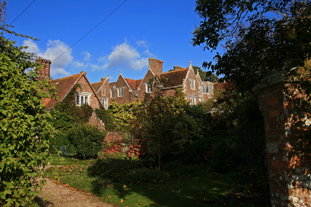
English: Anderson Manor Anderson Manor was built in 1622 for John Tregonwell, and was described three years later in Coker's Survey of Dorsetshire, as a 'faire newe house'. In more recent times it was taken over by the War Dept. during the Second World War, and became the headquarters for the Small Scale Raiding Force of 62 Commando. After the SSRF disbanded in 1943, Anderson Manor ended its wartime role as Station 62 under the Special Operations Executive (S.O.E.). The house is Grade I Listed.
|
|
| Dabisili kalinli | ||
| Nyabli | From geograph.org.uk | |
| Sab'sabira | Mike Searle | |
| ŋmahinli (required by the license) | Mike Searle / Anderson Manor / | |
| Camera location | | View this and other nearby images on: OpenStreetMap |
|---|
_heading:22.00&language=dag)
| Object location | | View this and other nearby images on: OpenStreetMap |
|---|
_heading:22.00&language=dag)
Fukumisi shahira niŋbu

|
This image was taken from the Geograph project collection. See this photograph's page on the Geograph website for the photographer's contact details. The copyright on this image is owned by Mike Searle and is licensed for reuse under the Creative Commons Attribution-ShareAlike 2.0 license.
|
This file is licensed under the Creative Commons Attribution-Share Alike 2.0 Generic license.
ŋmahinli: Mike Searle
- A mali sɔli:
- N pirigi – Diyi lee ka a yan labi ŋma, n tari ka yan zaŋ tuma n talim
- Lab laɣim – n taɣi dee tuma maa
- N-yɛn zaŋ dɔli zalikpana ŋɔ sɔli:
- ŋmahindibu – Di tu ni a ti nin'tiɣili din tu, ka yooi sɔli din yihiri shiɛhira gbaŋ, ka lahi wuhi di yi niŋ ka taɣibu daa pun niŋ. A ni tooi niŋ lala ŋɔ n-doli hankali ni saɣi shɛm, amaa ka di pa sɔ'shɛli din mali biɛhiŋ zaŋ kpa ŋun tiri shiɛhira gbana ŋɔ polo nin'tiɣili ni nyini bee a zaŋ tum.
- Tarimi li din nyɛ shɛm – A yi mali labi sabi bee a taɣi li mi bee a miɛmi n-tam sabiri kurili maa zuɣu, di tu ni a tari a tɔhibu maa doli same or compatible license n-zali maŋ-maŋ maa.
Faal tarihi
Dihimi dabisili/saha n-nya kɔl' bihi kamani di ni di yina shɛm
| Zuŋɔ dabisili/Saha | Thumbnail | Di tarisi | ŋun su | tɔhibu | |
|---|---|---|---|---|---|
| din na chana | 22:22, 6 Silimin gɔli February 2011 | | 640 × 426 (197 KB) | GeographBot | == {{int:filedesc}} == {{Information |description={{en|1=Anderson Manor Anderson Manor was built in 1622 for John Tregonwell, and was described three years later in Coker's Survey of Dorsetshire, as a 'faire newe house'. In more recent times it was taken |
Lahibali kɔligu zaŋ tum tuma
Din doli ŋɔ na yaɣili tuma nima zaŋ ti lahabali kɔligu ŋɔ:
Duniya zaa lahabali kɔligu zaŋ tum tuma
Wikis shɛŋa ŋan dolina ŋɔ gba malila faal ŋɔ n kuri bukaata:
- Zaŋ tum tuma ceb.wikipedia.org zuɣuc
- Zaŋ tum tuma cy.wikipedia.org zuɣuc
- Zaŋ tum tuma da.wikipedia.org zuɣuc
- Zaŋ tum tuma en.wikipedia.org zuɣuc
- Zaŋ tum tuma fr.wikipedia.org zuɣuc
- Zaŋ tum tuma it.wikipedia.org zuɣuc
- Zaŋ tum tuma nl.wikipedia.org zuɣuc
- Zaŋ tum tuma pl.wikipedia.org zuɣuc
- Zaŋ tum tuma ur.wikipedia.org zuɣuc
- Zaŋ tum tuma www.wikidata.org zuɣuc
- Zaŋ tum tuma zh-min-nan.wikipedia.org zuɣuc